Map of Egypt
Map of Egypt > Egypt Locator Map • Egypt Travel Tips • Egypt Relief Map • Cairo Map
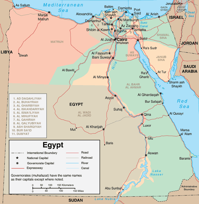
Egypt Map, Showing Major Cities and Administrative Divisions
Geography of Egypt
After Nigeria, Egypt is Africa's second most populous country. Because Egypt is mostly desert, most of its inhabitants reside either in the fertile valley of the Nile Delta or along the Suez Canal, which connects the Mediterranean and Red Seas.Egypt has three other main regions in addition to the Nile Valley. Its Western and Eastern deserts are part of the Sahara, while the Sinai Peninsula, which is located to the east of the Suez Canal, contains Gebel Katharina (or Mount Catherine), Egypt's highest peak, in addition to several other mountains. Mount Catherine is Egypt's highest point at 8,625 feet (2,629 meters).
Egypt's Climate
The desert climate in Egypt means that it is one of the world's sunniest locations, with very little rainfall. What rainfall there is occurs during the mild winter months. And while Egypt does enjoy being one of the sunniest places on earth, the climate can have its challenges. During the summer it's not uncommon for hot winds to blow sand and dust into the Nile Valley, making atmospheric conditions less than perfect.
Leading Egyptian Cities
Cairo, Egypt's capital city, was a cradle of ancient civilization and lies at the intersection of Africa and Asia. It is the chaotic, unpredictable home to over 11 million Egyptian, Arab, and African residents. Famous archaeological sites such as the Sphinx and the Great Pyramid of Giza are fairly close by. Cairo is also home to more than 400 religious mosques, as well as plentiful Islamic architecture and art. Cairo has five universities, one of which is the world's oldest.Alexandria, the second largest city in Egypt, is situated along the Mediterranean Sea to the west of the Nile river delta. It is a popular resort area, featuring a temperate climate and scenic, white sand beaches. Its lighthouse was one of the wonders of the ancient world.
Egypt Travel and Tourism
One of the great early civilizations, tourists are drawn to Egypt to view its pyramids, temples, and decorated tombs. While Arabic is Egypt's official language, French and English are also commonly spoken. Currency is the Egyptian pound. For more information on traveling in Egypt, visit the Egyptian Tourist Authority website, which provides information about ancient and modern Egypt.
Egypt Resources
- CIA - The World Factbook - Egypt - U.S. government almanac of Egypt offering maps, statistics and geography.
- Wikipedia - Egypt - This free online encyclopedia includes information about Egyptian history and geography, as well as regions in Egypt.
- Egypt News - News headlines and news article links about current events in the nation of Egypt.
Related Map Websites
- Map of Africa - maps of the African continent.
- Map of Greece - Greece maps and travel info.
- Map of Italy - Italy maps and travel info.
All rights reserved. About us.
Certain maps hereon are © Map Resources.